
This is somewhat of a cross-post from one that I wrote for our K-State Spanish blog last week, and I wanted to share and expand on it a bit here. One of my main goals in teaching second-language (L2) Spanish Literature courses is to develop non-traditional tasks that demonstrate the value of reading for the development of the target language. Students often perceive literature classes as boring, difficult, or irrelevant — and to be honest, who can blame them? Literature pedagogy, in either the L1 or the L2 leaves much to be desired… if it exists at all, and most literature professors have not studied or been trained in pedagogy beyond the language-teaching aspect of their jobs (and many research faculty do not end up teaching those traditional basic language courses) (see Bernhardt). Moreover, students are intimidated by reading longer texts or complex literature in their target language, and they are quick to get discouraged and fault their language skills if they misunderstand something in the text. But understanding and interpreting a story in your L2 depends as much, if not more, on cultural and historical knowledge and context as on language skills. So, for students with less experience or background in literary studies, or those who may be a bit resistant to or less enthusiastic about a “sCaRy SpAnIsH LiTeRaTuRe” class, I like to think about and present analyzing literature as simply collecting and interpreting data — which it is!
Framing literary analysis as data collection, allows me to design projects or assessments that combine visual and textual elements to present an argument, which is often a more accessible way for my Spanish students to synthesize information and arrive at a thesis statement in their L2. The visual elements also allow them to easily share their project with an audience that goes beyond simply me, the professor. For example… at the end of a normal literature or culture seminar, students do not read each others’ term papers, nor do they necessarily gain much insight from a peer’s oral presentation; but when designing creative visuals in a medium they are comfortable using, they can “see” their classmates interpretation of a text and are more curious and inclined to ask questions about the chosen content and design. This curiosity and comparatively low-effort processing of their peer’s work implicitly leads to further discussion of the literary text. I do this a lot with Snapchat and, as a next step, I decided to use mapping principles to experiment with a new visual format of presentation that would account for what I call a “medium-mismatch” in terms of where students demonstrate critical thought and how we often expect them to present it in the traditional essay-based L2 literature classroom (see Bender).

To encourage students to practice and adapt their developing skills of literary analysis outside a traditional research paper or essay — especially during a hyflex semester when we were finishing the final two weeks exclusively online, and I KNEW we would all be prematurely exhausted from mixed modalities and Covid-uncertainties — I created a map-based final project for my Fall 2020 seminar, “Mapping Madrid in the Edad de Plata (1898-1939)”. I wanted their non-traditional final project to creatively combine principles of cartography and narrative analysis. Back in September (2020) I briefly mentioned this project and plans in a blog post as the semester was just getting started, and so this is a follow-up post with some results and reflection. As I said, this was an experimental project during an experimental semester sort-of-back-on-campus-hyflex-course. Despite some re-opening of K-State’s campus, there were still ongoing uncertainties surrounding scheduling, attendance due to isolation or quarantining, and the use (or restriction) of spaces on campus. For this project, students could choose to pursue a “narrative cartography“, which I like to think of as a geographically-informed map that conveys a certain narrative (story) based on an analysis of the text or a theme… OR a “cartographic narrative“, which is more artistic or abstract, conveying a narrative about the text or chosen theme through mapping principles (rather than a precise map itself).
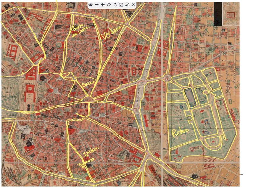
That is to say, that a “narrative cartography” relies on a traditional, recognizable “mapping” layout and design, whereas the “cartographic narrative” simply alludes to geospatial or location-based data in its design. Here are two images I used to think of the differences:

Throughout the semester, we read two full-length Spanish novels of about 200-pages each — Carmen de Burgos’ La rampa (1917) and José Díaz Fernandez’s La Venus mecánica (1929). Students also read a variety of articles and essays on early 20th-century Madrid, Literary & Artistic Avant-garde movements, and women’s participation in public and private aspects of urban live and city spaces in the 1920s. To associate plot-points in these novels with the real, historical places upon which they were based, we consulted various historical and contemporary maps of the Spanish capital, ranging from the 18th-century to the present day via Google Maps. This high-resolution map of early 20th-century Madrid at the Bibliotheque Nacional de France is one of my favorites, and I blogged about its details in an earlier post, 1900s Madrid, in Narrative and a High-Resolution Map. I also provided them with several examples of mapping projects connected to literature — which are becoming increasingly popular. For example, to celebrate the centenary of the death of Spain’s renowned 19th-century novelist Benito Perez Galdós, Madrid’s Área de Cultura, Turismo y Deporte commissioned a “Madrid es Galdós” map containing various tourist routes corresponding to places appearing in Galdós’s novels. The publishing firm Aventuras Literarias has also published a map of 1873 Madrid in which more than 150 places from Galdós’s novels appear — it’s now in it’s 6th edition. These are just two examples, and I’ll save a few more for a new post.
In addition to the examples above, below are a few more samples of what students came up with for their final projects:

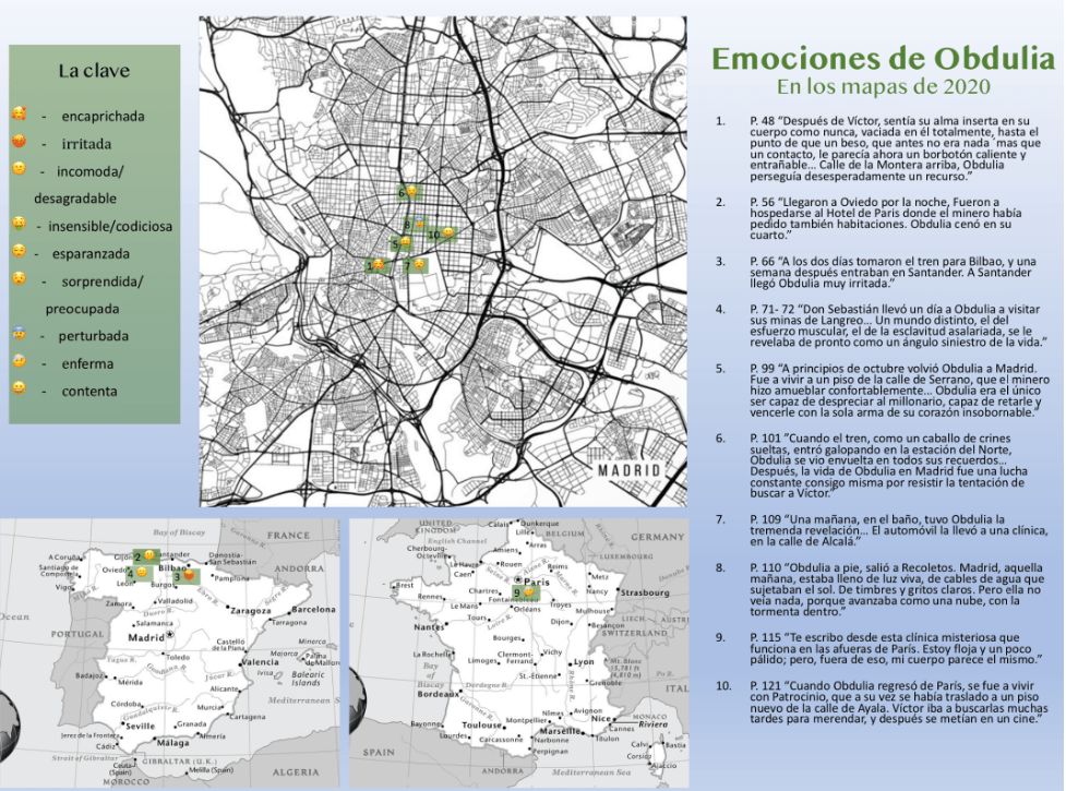
Overall, there were many benefits to this approach. As you can see from two examples above, my class noticed that most board games are in fact “maps” that require players to embark on a journey. They hadn’t necessarily reflected upon or thought critically about this design concept before brainstorming mapping ideas for the literary “journeys” and settings of the novels they read. This is a great example of how Spanish literature classes can encourage students to think differently about purportedly familiar cultural objects and their own lives and experiences — in their target language. Additionally, two students were able to continue working on their projects beyond Fall semester. Anna Welsh (whose projects is the very first image on this blog) applied for a $500 student research grant through Kansas State University’s Office of Undergraduate Research and Creative Inquiry (OURCI) office, and she was awarded funds this Spring. She is currently finishing additional secondary research and a re-design of the project under my supervision. She’ll be featured in K-State’s Seek Research Magazine soon, and Anna and I are working to identify ways to collaborate with Spanish bookstores and the Fundacion Carmen de Burgos to help promote the vast literary production of “Colombine”, whose works are increasingly, and fortunately, being published in modern Spanish presses. We’re hoping to reach a small international audience with her attractive narrative cartography. Another student, whose work is the final image above (on emotions) is also expanding her research to fulfill requirements for her International Studies Capstone course this Spring semester. Working with these two undergraduate students now, during Spring semester — on a project they began in fall — is also making me realize the time investment required in traditional literary essays and term papers. I think that too often, Spanish (L2) literature professors expect too much for a final essay or traditional term paper that students generally begin during the final few weeks of the semester. As we know as researchers, solid projects take a lot of time to develop, not simply because of the reading, but because of the time and distance required to THINK. And this is especially true for undergraduate students who are still developing their L2 language skills in our classes. Finally, during this crazy semester in particular, students felt less stressed creating a project like this than if I were to have asked them to produce an 8-12 page research paper; some of the science and business majors (dual-majors) especially appreciated this, and I clearly got original work from everyone.
Of course there are some drawbacks and some things that I need to iron out and improve — especially when I implement this during a “normal” semester back on campus, whenever that will be. For one, I will need to give them more specific guidelines, such as how many secondary sources to cite and how to design their reflection papers. In connection, I need to find better parameters for formal assessment. Again, I took advantage of the uncertainties surrounding Fall 2020 to engage with a more experimental and flexible approach that would not necessarily be as productive or appropriate in a “normal” 15-week on-campus semester. Additionally, and perhaps deceivingly, the creation of an effective, attractive, and legible narrative cartography/cartographic narrative takes a LOT of time; just as much if not more than preparing a traditional research paper. I think a productive adaptation of this project would be to encourage students to work in pairs or groups of three so that they could combine resources and share the time investment — and diverse skill sets — required to complete this project. I’d also like to find a better resource to outline cartographic data concepts, so that they could align their creation with very specific cartographic principles. For this course, I used the 4 principles of “procesos cartograficos” outlined here, mostly because it was an open-access resource IN SPANISH; I like to use Spanish-language resources as much as possible in advanced seminars, since my K-State students are ultimately working on continuing to improve their Spanish language proficiency. I’ve since found a few great sources on map-design and cartography & narrative, but most of them are in English. If you have any recommendations, send them my way!
What are some non-traditional projects or tasks you have used to teach (L1 or L2) literature? Have you seen any literary mapping projects (like the aforementioned Galdós maps) directed at a general audience lately?
RESOURCES:
For this course, I maintained a hashtag — #MappingMadridKSU — so that any relevant resources or additional information or images I found during the semester could be saved, informally shared, and perhaps incorporates into a future version of this course (the link indexes them in reverse chronological order).
Bender, Rebecca M. (2020). “Snapping the Quijote: Examining L2 Literature, Social Media, and Digital Storytelling through a Cervantine Lens.” Hispania, vol. 103, no. 3, pp. 323-39. –> Blog summary here.
Bernhardt, Elizabeth (2001). “Research into the Teaching of Literature in a Second Language: What It Says and How to Communicate it to Graduate Students.” In Scott and Tucker, pp. 195-210.
Nance, Kimberly A. (2010). Teaching Literature in the Languages. Expanding the Literary Circle through Student Engagement. Prentice Hall.


Pingback: Americans in Spain (1820-1920): Traveling Women Artists and their Subjects | Rebecca M. Bender, PhD
Pingback: Unveiling the National Geographic’s Choice: The World Map on Their Cartography – CHM