As I’ve mentioned several times before, I’m very much a map nerd — I LOVE reading maps, finding creative interpretations of cities and spaces to display in my office (like my literary map of Madrid and my caricatured map of Mexico), and exploring how the geography and physicality of a space relates to its appearance or representation in art and literature. This past summer (2018) I found an over-sized color copy of the 1656 Teixeira map of Madrid, and I finally re-organized my office over winter break to display it behind my desk. I bought it for only about 8 euros at a kiosk in the Plaza Santa Barbara, if I recall correctly, and with my Madrid and Mexico maps, it really ties the room together…!

My beloved trio of maps #OfficeDecor
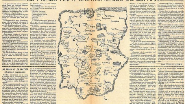
Over a year ago now, as I was researching silver age illustrations and kiosk literature cover designs for a project on Carmen de Burgos, I came across a “gastronomic map” created by Ramón Gomez de la Serna that was featured in one of Burgos’ cookbooks, Nueva cocina práctica (1925). The map, below, carries the title, “Mapa gastronómico-humorístico,” or “Humorous gastronomic map,” and it instantly set me on a quest for more information.

Ramón’s map as it appears on the pages of Burgos’ 1925 Nueva cocina practica. Image mine (screenshot), via the Biblioteca Nacional de Espana. Ingram’s article (p. 80) contains a cleaner image courtesy of Madrid’s Hemeroteca Municipal
First, I found Rebecca Ingram’s article, “Mapping and Mocking: Spanish Cuisine and Ramón Gómez de la Serna’s “El primer mapa gastronómico de España” (pdf), which explores the map and Ramon’s somewhat ironic commentary on it within the social and historical context of 1920s Spain. As it turns out, the map that I had “discovered” in Burgos’ cookbook was not the first iteration, nor was it the first time Ramon’s cartographic artwork had appeared in print. Ingram explains that it had been published a year before, in 1924, when Ramón penned a column for the satirical weekly journal Buen humor, which ran for a decade between 1921-31. Below is the “original” version of the map, which is very similar to the clear copy that appeared in Burgos’ cookbook (above). While the map reflects regional specialties that in some cases are still popular today — Madrid’s traditional stew, el cocido madrileño; Galicia’s traditional soup, el pote gallego; Segovia’s chorizo de Cantimpalo; cheese from Burgos; and Avila’s pastries, las yemas de Santa Teresa — their placement and inclusion on the map does not necessarily indicate that they were the most popular or commonly consumed dishes or delicacies of their day.
Ramon’s original “Gastronomic map” and editorial, published in “Buen Humor,” 1924. Image via El español.
While maps purport to offer a reflection of a geographical area with as much scientific and technical accuracy as possible, Ingram observes that Ramón’s humorous creation points out the inherent subjectivity of maps as authoritative, official documents (84). In her article, she analyzes the short narrative text that Ramon penned to accompany his map, in which he creates a fictional, traveling mapmaker and several local Spanish interlocutors. Through his comic tale of an ill-informed mapmaker’s trip through Spain, together with his abstract and arbitrary depiction of Spanish geography (poor scale; selection of cities and towns; inclusion of Portugal), Ingram interprets Ramon’s project as a critique not only of “official” or “authoritative” cartography — and gastronomy — but of the legitimacy of the skills and qualifications of those who create such images and narratives (88-89). She even links this critique to the Spanish national project, arguing that the map (visual) and the vignette (text) together communicate that “Spain’s attempt to disguise itself as a nation sufficiently modernized that a national gastronomy can be meaningful is unmasked by Ramón’s description of the bumbling cartógrafo [mapmaker] (94). Ingram’s article is an exceptional close-reading of Ramón’s text and his cartographic creation, and in fact would be useful to use in an advanced seminar on Spanish culture or literature. It may also serve as a model for students as to how maps, or other official displays (museums, exhibitions, monuments) may be examined and analyzed precisely for the narratives that they convey — either directly or implicitly — and how these narratives may be interpreted by different viewers. In fact, I’m now considering using a few excerpts of the article in my pre-departure readings for my study abroad program in Spain this summer.
I’ll conclude this post with a few more “mapas gastronomicos” that I found during my light research for this blog post… one of which merits a bit more research in the future, and others that are mostly for fun! The first is a map that appeared as part of a fold-able pamphlet created for the 12th Official International Trade Fair in Barcelona, June 10-25, 1944:
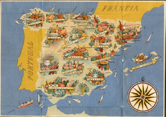
Image via Vivanco
According to the Museo Fundación Vivanco, where the map and the entire booklet are displayed, the back of this colored map-booklet contains 20 blue-framed text boxes, each of which highlights a recipe from the “various ancient regions of Spain, from Asturias to Navarra.” In the center is the map title, “Mapa Gastronómico de España. Platos de sus regiones” (Gastronomic Map of Spain. Dishes from its regions), accompanied by the logo of Barcelona’s Trade Fair and the crest of the old Franco Regime (el escudo del Antiguo Régimen Franquista). I’ve included a few extra images below, taken from Vivanco’s Museum page dedicated to the map:


The “fun” maps below show the continued popular appeal of both national gastronomy and creative cartography, and I found the following selections via Twitter and a simple Google Image search for “mapa gastronomico.” In this era of Instagram, Twitter, and other forms of (social) media that aim to communicate information in the fastest, most visually appealing or digestible (pun intended!) way possible, the gastronomic map is extremely relevant for promoting national and local economies in terms of tourism. For example, Iberica’s advertisement for Spanish Foods in the UK is visually appealing and also loosely based on the gastronomy-geography connection: Pulpo (squid, octopus) covers Galicia; Queso manchego (Manchego cheese) appears over the La Mancha region; and aceitunas (olives) make up Andalucia:

Similarly, an interactive map can be found over at CartoVision, a blog dedicated to “viewing the world through the perspective of maps,” that places specialty dishes over the region to which they are most closely associated. The screenshot is below, but you can visit the interactive map here to click on each part, prompting a pop-up box containing the name of the region and the dish.

Image via CartoVision.es
And for the last example, you can watch this “relaxing” YouTube video that assembles beautiful regional foods into colorful culinary map-sculptures — including Spain, Italy, and Greece. But I wouldn’t watch on an empty stomach… you’ll surely want to pour a glass of wine and make a tapas platter right away!
What are some creative or unique MAPS that you’ve seen lately? Have you used MAPS in a literature or culture course for purposes other than to illustrate geography? I’d love to hear your thoughts in the comments!
Resources:
Ingram, Rebecca. “Mapping and Mocking: Spanish Cuisine and Ramón Gómez de la Serna’s “El primer mapa gastronómico de España”. Cincinnati Romance Review, vol. 33, 2012. Link to PDF.
El Espanol‘s Spanish post (2017) about Ingram’s article, Ramon’s map, and Spanish gastronomy: “El primer mapa gastronomico de Espana: Los hitos culinarios segun el gusto de 1924“.


Fascinating! Thanks for this informative post!
Glad you enjoyed it! I had fun gathering all these fantastic images… even if it made me hungry 🙂
Wow, this is incredibly interesting!
Isn’t it? It makes me want to start Food-Mapping all my travels…!
You should!
Pingback: Rebecca M. Bender, PhD